

The High Cost and Lock-In of Proprietary Mapping APIs
When building location-aware web applications, engineering teams frequently default to commercial mapping platforms like Google Maps or Mapbox. However, relying on proprietary mapping APIs introduces significant operational liabilities:
- Aggressive API Billing Thresholds: Commercial tile and geocoding services bill on a per-request basis. A sudden surge in user traffic or a distributed scraping bot can lead to unexpected billing spikes.
- Restrictive Terms of Service: Vendor terms often prohibit caching geocoding results locally, combining data from other map providers, or utilizing offline maps without high-tier enterprise licenses.
- User Privacy and Data Tracking: Integrating third-party map scripts forces user browser sessions to share telemetry, IP addresses, and interaction patterns with corporate tracking infrastructure.
- Vendor Lock-In: Deeply coupling frontend components to proprietary SDKs makes migrating to self-hosted or alternative tile providers time-consuming and expensive.
OpenStreetMap (OSM) eliminates these constraints by providing an open, crowdsourced database of geographic data licensed under the Open Database License (ODbL). Paired with lightweight rendering libraries like Leaflet.js, OSM enables developers to build custom, privacy-focused mapping applications without licensing fees.
What Is OpenStreetMap?
OpenStreetMap is a global, community-driven spatial database. Rather than functioning solely as a static image service, OSM stores structured vector data comprising nodes, ways, and relations.
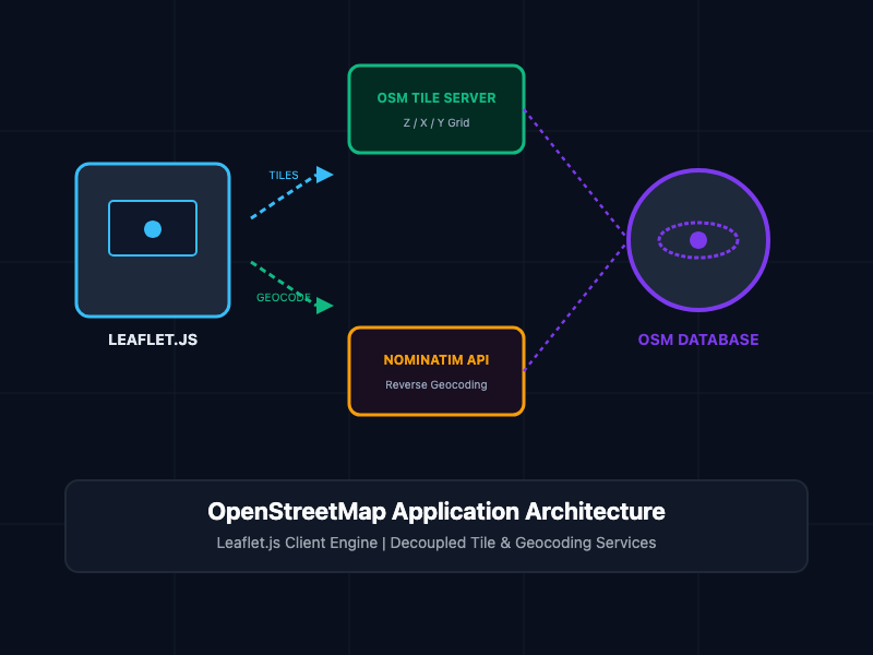
To display an OpenStreetMap map inside a web browser, the application architecture relies on three decoupled components:
- Tile Server: Converts raw geographic data into image tiles (PNG/WebP raster format) or vector tile payloads organized in a standardized $Z/X/Y$ grid structure.
- Rendering Engine (Leaflet.js): A lightweight JavaScript library that runs inside the client browser, fetching tile images dynamically, handling drag/zoom user interactions, and rendering vector overlays.
- Geocoding Engine (Nominatim / Overpass): External APIs that convert human-readable addresses into latitude/longitude coordinates (forward geocoding) or vice versa (reverse geocoding).
Core Concepts and Implementation
1. Rendering Interactive Maps with Leaflet.js and OSM Tiles
Leaflet.js is an open-source JavaScript library designed for mobile-friendly interactive maps. It interfaces directly with OpenStreetMap tile servers to render interactive viewports with minimal footprint (~42KB).
The following HTML and JavaScript implementation demonstrates how to initialize a Leaflet map, attach OpenStreetMap tiles, and bind interactive markers with custom popups:
<!DOCTYPE html>
<html lang="en">
<head>
<meta charset="UTF-8">
<meta name="viewport" content="width=device-width, initial-scale=1.0">
<title>OpenStreetMap Integration with Leaflet.js</title>
<!-- Import Leaflet CSS Stylesheet -->
<link rel="stylesheet" href="https://unpkg.com/leaflet@1.9.4/dist/leaflet.css" />
<style>
#map {
height: 500px;
width: 100%;
border-radius: 8px;
}
</style>
</head>
<body>
<div id="map"></div>
<!-- Import Leaflet JavaScript Engine -->
<script src="https://unpkg.com/leaflet@1.9.4/dist/leaflet.js"></script>
<script>
// 1. Initialize map centered at target coordinates [latitude, longitude] and zoom level
const map = L.map('map').setView([51.505, -0.09], 13);
// 2. Attach OpenStreetMap tile layer with required attribution
L.tileLayer('https://tile.openstreetmap.org/{z}/{x}/{y}.png', {
maxZoom: 19,
attribution: '© <a href="https://www.openstreetmap.org/copyright">OpenStreetMap</a> contributors'
}).addTo(map);
// 3. Add an interactive marker with a popup message
const marker = L.marker([51.505, -0.09]).addTo(map);
marker.bindPopup("<b>Data Center Alpha</b><br>Primary Node Location.").openPopup();
</script>
</body>
</html>
2. Reverse Geocoding with Nominatim API
Converting clicked coordinates on a map into a physical street address requires a geocoding service. Nominatim is the open-source geocoding engine powered by OpenStreetMap data.
This asynchronous JavaScript snippet captures map click events, queries the Nominatim API, and returns the formatted address:
// Function to execute reverse geocoding via Nominatim API
async function reverseGeocode(lat, lon) {
  const endpoint = `https://nominatim.openstreetmap.org/reverse?format=jsonv2&lat=${lat}&lon=${lon}`;

  try {
    const response = await fetch(endpoint, {
      headers: {
        // Enforce custom User-Agent per Nominatim Usage Policy
        'User-Agent': 'EnterpriseMapApp/1.0 (admin@yourdomain.com)'
      }
    });

    if (!response.ok) {
      throw new Error(`Geocoding HTTP error: status ${response.status}`);
    }

    const data = await response.json();
    return {
      displayName: data.display_name,
      address: data.address
    };
  } catch (error) {
    console.error('Reverse geocoding failure:', error.message);
    return null;
  }
}

// Bind click listener on Leaflet map instance
map.on('click', async (event) => {
  const { lat, lng } = event.latlng;

  // Create temporary marker
  const tempMarker = L.marker([lat, lng]).addTo(map);
  tempMarker.bindPopup("Resolving location address...").openPopup();

  const locationData = await reverseGeocode(lat, lng);
  if (locationData) {
    tempMarker.setPopupContent(`<b>Location Address:</b><br>${locationData.displayName}`);
  } else {
    tempMarker.setPopupContent("Failed to resolve physical address.");
  }
});
Architectural Comparison
| Dimension | OpenStreetMap + Leaflet.js | Google Maps JavaScript API |
|---|---|---|
| Licensing | Open-source (ODbL / MIT) | Proprietary Commercial |
| Usage Cost | Free (Self-hostable or community tiles) | Per-1000 requests after free tier |
| Data Ownership | 100% Client and server control | Vendor controlled & subject to terms |
| Bundle Size | ~42KB (Leaflet core library) | ~200KB+ (Google Maps JS SDK) |
| Offline Capabilities | Supported via cached tile stores | Restricted by Terms of Service |
| Geocoding Terms | Results can be stored permanently | Results caching strictly limited |
SRE and Production Best Practices
- Respect Public Tile Server Usage Policies: The default tile.openstreetmap.org servers are operated entirely on donated community resources. For high-traffic production workloads, deploy your own tile server (using Renderd/TileServer-GL) or utilize commercial OSM tile providers (such as Stadia Maps, Jawg, or MapTiler).
- Enforce Caching via Reverse Proxies: Place a CDN (e.g., Cloudflare, Fastly) or Nginx reverse proxy in front of your tile endpoints to cache static PNG/WebP tiles aggressive across edge nodes.
- Set Custom User-Agent Headers for Nominatim: Nominatim strictly blocks generic HTTP clients. Always supply a unique User-Agent string containing your application name and contact email in header parameters.
- Pre-Render Vector Overlays: When displaying thousands of spatial coordinates, render vector shapes using WebGL layers (such as MapLibre GL JS or Leaflet.Canvas) rather than creating thousands of separate SVG DOM elements to maintain 60fps interaction performance.
Getting Started
To launch a production-ready open-source mapping stack:
# Step 1: Install Leaflet via NPM for modern bundlers (Vete, Webpack, ESBuild)
npm install leaflet

# Step 2: Import Leaflet module inside your JavaScript entrypoint
# import L from 'leaflet';
# import 'leaflet/dist/leaflet.css';

# Step 3: Test local map execution
npx serve .
By decoupling your mapping pipeline using OpenStreetMap and Leaflet.js, you eliminate recurring API charges, preserve user privacy, and gain full operational control over your geographic data infrastructure.